|
In
addition to the disruption in the ocean flow caused by Frying
Pan Shoals, Cape Fear has several other unique geographical
features that are positive attributes for the fishing. First
and most obvious is the nearby Cape Fear River, which is only
a few miles to the west. From its beginnings above Greensboro,
the Cape Fear River grows into one of the largest river
systems in the southeast and is the only large river in North
Carolina that empties directly into the ocean.
About
the same distance up the East Beach of Bald Head Island,
Corncake Inlet empties from the fertile estuaries behind Bald
Head Island and the Fort Fisher State Recreation Area. This is
not a navigable inlet as it is very small and shallow, but its
direct link to the nursery areas makes it a major fish
attractor. The ebb and flow of small fish and shrimp through
this inlet, is the beginning of a food chain that contains
many levels. King mackerel, tarpon, sharks, red drum, and
dolphin (mammal) are the top predators just offshore of
Corncake Inlet.
Access to the ocean waters around Cape
Fear is easily available. Approximately four miles to the west
(south), the Cape Fear River includes the shipping channel for
the North Carolina State Ports at Wilmington. There is also
another well used, but unmarked channel, that is shown as the
Western Bar Channel on most charts and is called the West Cut
locally. It is heavily traveled but unmarked and following
someone through is recommended, at least for the first
time.
Another 15 miles to the west is Lockwood Folly
Inlet. This is a typical North Carolina small inlet that can
be rough at times but is heavily used. Lockwood Folly is well
marked, but sometimes shoals quickly. Pay attention to the
markers and the breaking waves and you should have no problem
on any day that the sea conditions are comfortable enough to
fish. Eight miles west of Lockwood Folly is Shallotte Inlet.
This inlet, which is well marked, is subject to the same
shoaling as Lockwood Folly, but was dredged during 2001 and is
continuing to hold good depths at this time.
Roughly 14
miles to the north of Cape Fear is Carolina Beach Inlet. While
it was dredged in early 2001, Carolina Beach Inlet may well be
the trickiest of any of the marked inlets in the area. It is
not uncommon to see buoys resting on their side in shallow
water as you pass through Carolina Beach Inlet. The channel,
which is deep enough for the local charter and commercial
fleet, moves around a bit and requires frequent maintenance.
Another eight miles to the north is Masonboro Inlet. Enclosed
by rock jetties, deep, and well marked, this is the best inlet
on the north side of the cape. |
 |
 |
|
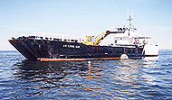
Building an artificial reefHere workers on
the R.V. Longbay lower another reef ball onto another
one of the nearshore reefs in Long Bay. Note the beach
in the right near
background. |
A feature of Cape Fear
that endears it to many fishermen is the fact that the
coastline makes a 90 degree bend there and creates a lee from
the predominant winds. The southern beach faces to the south,
while the northern beach faces to the east. The predominant
spring and summer wind is from the southwest and becomes
predominantly northeast during the fall and winter. With the
turn at the cape and good inlets close by on both sides,
fishermen can find a near shore lee for comfortable fishing
during most of the year.
As I said earlier, there are
kings in the waters around Cape Fear all year. Let's look at a
typical year beginning in January. The tip of Frying Pan
Shoals is close enough to the Gulf Stream that it tends to
collect stray eddies during the winter and even create a few
of its own. These fingers of warmer water will often settle
around Frying Pan Light Tower and hold fish until the water
blends with the cooler water and disappears. Usually by then,
another finger or eddy is moving in with more fish.
While there isn't an abundance of recreational fishing
during the winter, the fish are around for those who try. The
kings generally aren't large, but there is a major winter
commercial king fishery in the waters near Frying Pan Tower.
If you ask nicely, many of these commercial fishermen will
help you get on a winter king bite during one of those
stretches of good weather that we often have. While it is a
long ride, a limit of winter kings sure helps cure a dose of
land sickness or cabin fever.
Sometime in late March or
April, the winds get back to a more southerly flow and push
some warmer water closer inshore. First, the kings show up at
many of the wrecks in 100 feet of water and then slowly begin
moving in. By early May they are usually at the Horseshoe and
WR 4 and getting closer as the water warms. The winds become
predominantly northeast and this trend reverses itself in
November and December as the water cools and the kings move
back
offshore.
|