Designs for Artificial Reef
Sites in the Indian River Lagoon
Martin County, Florida
Submitted to:
Kathy FitzPatrick, P.E.
Martin County Coastal
Engineer
Martin County Administrative
Center
2401 SE Monterey Road
Stuart, FL 34996
Prepared by:
Lee E. Harris, Ph.D., P.E.
Consulting Coastal Engineer
310 Ormond Avenue
Indialantic, FL 32903
February 2002
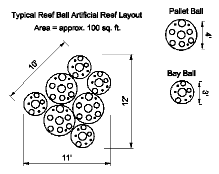
Project Design: Various sizes and weights of Reef BallTM artificial reef units are available, as presented in Table 1. Microsilica and other additives were used in the concrete to increase the strength and workability plus decrease the pH of the concrete to that of marine environment.
Table 1. Reef BallTM
Sizes, Weights, Volume & Number of Holes
Style
|
Width |
Height |
Weight |
Concrete |
No.
of |
|
Ultra
Ball |
6 feet |
4.5 feet |
4000-6000
lbs |
1 yard |
29-34 |
|
Reef
Ball |
6 feet |
4 feet |
3000-6000
lbs |
0.75
yard |
29-34 |
|
Pallet
Ball |
4 feet |
3 feet |
1500-2200
lbs |
0.33
yard |
17-24 |
|
Bay
Ball |
3 feet |
2 feet |
375-750
lbs |
0.10
yard |
10-16 |
Designs for Artificial Reef Sites in the Indian River Lagoon, Martin
County, Florida
This report presents the results of diver investigations for three proposed artificial reef sites in the Indian River Lagoon in Martin County, Florida. Data were collected by divers during field work performed in December 2001 and January 2002 for two areas:
1)two dredged holes located at the eastern end and just north of the Stuart Causeway 2)deeper areas offshore of the Martin County Indian Riverside Park.
Stuart Causeway Sites
At the eastern end of the Stuart Causeway there are two dredged holes north of the causeway, as shown in the Figure 1. Each of these 2 sites are approximately 600 feet offshore of the Hutchinson Island shoreline.
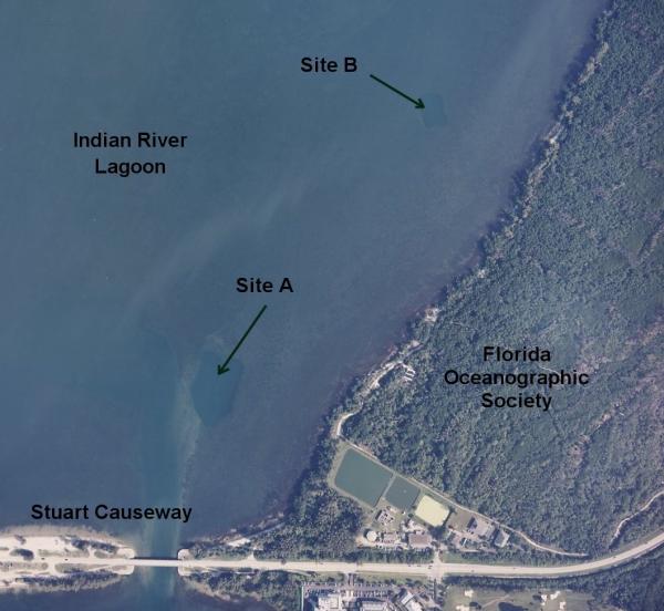
Figure 1. Locations of the Stuart Causeway Potential
Artificial Reef Sites
Site A
The southernmost site, Site A is located approximately 700 feet north and slightly east of the small eastern causeway bridge. Figure 2 shows an enlarged aerial photograph of this site, which is roughly 400 feet long by 250 feet wide. The actual shape is a pentagon, with the five vertices labeled as SW, S, SE, NE and NW. Water depths are shown in Table 1.
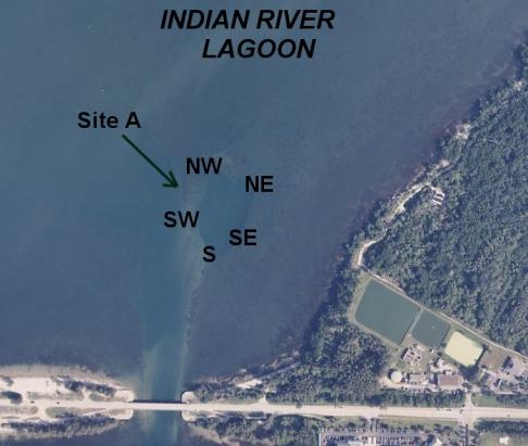
Figure 2. Site A
Table 1. Water Depths Adjusted for Tide (depth in feet below MLLW datum)
|
Location |
GPS Coordinates |
Depth @ Point |
Depth 50’ Inside |
Depth 50’ Outside |
|
SE |
27o 12.765 80o 11.172 |
8.6 |
11.4 |
3.8 |
|
NE |
27o 12.803 80o 11.168 |
7.4 |
11.7 |
4.2 |
|
NW |
27o 12.790 80o 11.212 |
13.1 |
13.0 |
6.3 |
|
SW |
27o 12.769 80o 11.216 |
8.2 |
13.0 |
4.7 |
|
S |
27o 12.742 80o 11.177 |
10.7 |
14.6 |
4.7 |
|
CENTER |
27o 12.770 80o 11.186 |
8.2 |
NA |
NA |
The water depths shown in Table 1 show that the average depth inside Site A is 12.7 feet below MLLW, with a maximum depth of 14.6 feet at the southern end.
Visual diver inspections were made for Site A on December 20, 2001 from 10am to 1pm EST. The results of these inspections are shown in Table 2. From the diver inspections, the bottom material for Site A consisted of sand and firm mud, with a maximum penetration by hand of 1.5 inches into the bottom. No seagrasses were found attached or growing on the bottom within Site A.
Table 2. Diver Inspection of Site A
Buoy Location GPS
coordinates Diver
bottom survey findings
SE 27o 12.765 Sand and firm mud, 1.5 in. penetration of hand
80o 11.172 into mud, midway between NE & SE buoy mud sand mixture is firm, no penetration, at SE buoy mud is softer with 1.5 in. penetration.
NE 27o 12.803
80o 11.168 Sand and firm mud, no seagrass, 1.5 in. penetration into mud.
NW 27o 12.790
80o 11.212 Sand and firm mud, no seagrass, 1.5 in. penetration into mud
SW 27o 12.769
80o 11.216 Firm mixture of sand & mud
Due S 27o 12.742
80o 11.177 Sand mud is firm at this location
Center of site 27o 12.770
80o 11.186 Firm mud, no seagrasses.
Outer perimeter of site N/A Firm sands with very little mixture of firm mud
Data collected on Thursday Dec. 20, 2001
By Kerry Dillon and Jack Glanville
Site B
Site B is located approximately 1900 feet northeast of Site A, and is approximately 600 feet offshore of Hutchinson Island. Figure 3 shows an enlarged aerial photograph of this site, which is roughly 200 feet long by 150 feet wide. The shape is nearly a rectangle, with the four vertices labeled as SW, SE, NE and NW. Water depths are shown in Table 3.
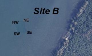
Figure 3. Site B
Table 3. Site B Water Depths Adjusted for Tide (depth in feet below MLLW datum)
|
Location |
GPS Coordinates |
Depth @ Point |
Depth 50’ Inside |
Depth 50’ Outside |
|
SE |
27o 13.130 80o 11.101 |
9.5 |
11.5 |
4.8 |
|
NE |
27o 13.146 80o 11.122 |
10.5 |
11.9 |
6.0 |
|
NW |
27o 13.134 80o 11.132 |
8.2 |
11.2 |
6.1 |
|
SW |
27o 13.122 80o 11.117 |
8.5 |
11.5 |
6.5 |
|
CENTER |
27o 13.130 80o 11.117 |
12.4 |
NA |
NA |
The water depths shown in Table 3 show that the average depth inside Site B is 11.7 feet below MLLW, with a minimum depth of 11.2 feet in the NW and maximum depth of 12.4 feet in the center.
Visual diver inspections were made for Site B on December 20, 2001 from 2pm to 4pm EST. The results of these inspections are shown in Table 4. From the diver inspections, the bottom material for Site BA consisted of soft mud, with a penetration by hand of at least 30 inches into the bottom. No seagrasses were found attached or growing on the bottom within Site B, but the soft mud does not provide a firm foundation to support artificial reef units.
Table 4. Diver Inspection of Site B
Buoy Location GPS
coordinates Diver
bottom survey findings
NE 27o 13.146 Soft mud, 2.5 ft. penetration of hand and arm
80o 11.122 into mud, unattached seagrass pieces and mangrove seeds laying on and in mud bottom
SW 27o 13.122 Soft mud, at least 2.5 ft. penetration of hand and
80o 11.117 arm into mud, red and green unattached seagrass pieces on top of mud. Do not appear to be attached or rooted.
SE 27o 13.130
80o 11.101 Soft mud at least 2.5 ft. deep
NW 27o 13.134
80o 11.132 Seagrass laying on top of mud. Does not appear rooted. No substrate to attach to, just soft deep mud at least 2.5 ft. deep
Center of site 27o 13.130
80o 11.117 Soft mud at least 2.5 ft. deep with seagrass loosely laying ontop of mud.
Outer perimeter of site N/A Sand, shell, and hard packed mud. Some grasses appear to be attached but are very sporadic. Water depth was consistent 6 ft.
Data collected on Thursday Dec. 20, 2001
By Kerry Dillon and Jack Glanville
Indian Riverside Park Pier Area
The area offshore of the Indian Riverside Park was investigated for possible artificial reef sites. Most of the area was too shallow and full of seagrasses, except for some areas around the existing pier structure. This area in the Indian River is shown in the aerial photograph in Figure 4.
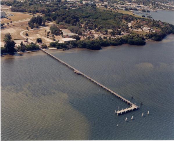
Figure 4. Pier at Indian Riverside Park
A close-up of the pier and surrounding area surveyed for possible artificial reef sites is shown in Figure 5, with the letters designating the locations of the depth measurements and diver inspections performed on January 11, 2002.
Table 5 presents a summary of the locations and depth measurements taken on January 11, 2002. Detailed description from diver surveys of the site are summarized in Table 6.
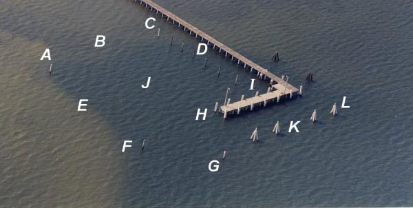
Figure 5. Designation of Points for Survey of Pier at Indian Riverside Park
Table 5. Locations and Depth Data in feet below MLLW
|
Buoy |
|
Time |
GPS Coordinates |
Water
Depth |
Depth
25' Inside |
Depth
25' Outside |
|
A |
SW
concrete piling |
10:30 |
27
13.456 |
3.4 |
6.9 |
1.4 |
|
|
|
80
12.598 |
||||
|
B |
Center
W Edge Basin |
10:35 |
27
13.474 |
6.4 |
6.9 |
2.9 |
|
|
|
80
12.600 |
||||
|
C |
PVC
piling at NW edge Basin |
10:42 |
27
13.486 |
3.5 |
4.4 |
2.2 |
|
|
|
80
12.606 |
||||
|
D |
3rd
wood pile from E |
10:47 |
27
13.488 |
7.5 |
7.2 |
7.7 |
|
|
|
80.12.589 |
||||
|
E |
Center
S edge Basin |
10:54 |
27
13.459 |
2.9 |
7.2 |
1.9 |
|
|
|
80
12.587 |
||||
|
F |
Concrete
Pile at SE corner Basin |
11:02 |
27
13.462 |
6.4 |
7.2 |
3 |
|
|
|
80
12.570 |
||||
|
G |
Outer
Channel Marker #4 |
11:10 |
27
13.472 |
4.8 |
4.4 |
3.4 |
|
|
|
80
12.558 |
||||
|
H |
PVC
Pile at s end “L” pier section |
11:20 |
27
13.480 |
8.8 |
8.7 |
NA |
|
|
|
80
12.573 |
||||
|
I |
PVC
Pile at NE corner of Basin |
11:25 |
27
13.495 |
7.6 |
7.8 |
NA |
|
|
|
80
12.579 |
||||
|
J |
Center
of Basin |
11:29 |
27
13.477 |
7.9 |
NA |
NA |
|
|
|
80
12.589 |
||||
|
K |
E of
Center of “L” Section of Pier |
11:45 |
27
13.493 |
5.3 |
8.3 |
3.6 |
|
|
|
80
12.566 |
||||
|
L |
NE
cluster pile seaward of pier |
11:50 |
27
13.501 |
4.9 |
6.2 |
4.1 |
|
|
|
80
12.565 |
Table 6. Bottom Survey Notes for Pier at Indian
Riverside Park
|
SW Piling A - Firm mud and sand at and around piling A |
|
South Side Basin - 25’ South of the A-E-F line: Firm sand and mud with randomly dispersed seagrasses, at the bottom of the slope is a mixture of soft sand and mud. |
|
West of Basin - 25’West of A-B line bottom is firm sand evenly distributed seagrasses. |
|
Southern 1/3 of Basin - 25’ North of A-E-F line and out to point G (marker 4): Soft mud, detached accumulations of seagrass at and around pint G, bottom changes to firm sand. |
|
Center of Basin- Along the H-J-B line to a point 25’outside the western border: Firm sand on east and west edges of the hole. In the deep area on the H-J-B line there is soft mud 2.5’ deep (min) hand penetration with randomly dispersed accumulations of detached seagrass. |
|
Northern 1/3 of Basin - 25-35’ North of H-J-B line the bottom is soft mud. Firm sand at outer edges of hole. Random dispersed accumulations of detached seagrass. |
|
North End of Basin - Along a line just south of the wood mooring piles. Soft mud. Random dispersed accumulations of detached seagrass. |
|
Along line between the south side of the pier and the north side of the mooring piles. Bottom becomes more of a mixture of sand and mud with more firmness to it. |
|
Along southern edge of pier a firm mixture of sand, shell and mud. |
|
Along eastern side of pier firm sand and shell, no seagrass. |
|
Northern side of pier out 100’ east to 10’east of 1st broken dolphin, firm sand and sporadic seagrass. |
|
North side of the pier and east of western most broken dolphin. Hard sandy bottom outside (north) dolphins. South of dolphins bottom slopes down and becomes soft mud. |
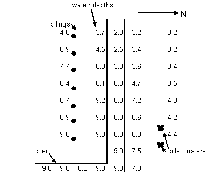
Figure 6. Water Depths at Pier at Indian Riverside Park (not to scale)
Conclusions
From the diver surveys of the two sites at the east end of the Stuart Causeway in the Indian River lagoon, the southern Site A was found suitable for artificial reefs, but the northern Site B was found unsuitable. Site B has sufficient depths, but the soft mud bottom with 30 inches and more of penetration into the bottom by hand would not provide support for artificial reef units.
The southern Site A was found to be suitable for artificial reef placement. This site is approximately 400 feet long and 250 feet wide which is about 2.2 Acres, and has an average depth of over 12 feet below MLLW. No seagrasses were found growing on the bottom of Site A, and the bottom is sand and firm mud, with only 1.5-inches of penetration by hand, so that sinking of reef units into the bottom would be minimal. The adequate water depths, firm substrate, and absence of seagrasses make Site A suitable for artificial reefs.
There are some areas in the vicinity of the Indian Riverside Pier that are suitable for artificial reef deployment. Floating docks are planned for the dredged basin south of the pier, so this area is not available for artificial reefs. The area immediately under the pier is suitable for artificial reefs over the eastern end and “L” portion where the depths are 5 to 9 feet below MLLW. The areas to the north and east of the pier are too shallow for artificial reefs, unless boat traffic is excluded from that area.